Our Services

Our Solutions

Innovative Geo Solutions

We deliver integrated geospatial solutions designed to address the complex challenges of modern resource and infrastructure management. By uniting cutting-edge technologies, automation, and data-driven methods, our approach ensures precision, adaptability, and efficiency—empowering clients to enhance business performance while optimizing the quality of every project delivered.

Explore the future of geo-intelligent solutions today. We transform geospatial complexity into clarity, enabling innovation and informed action.

PORTABLE MOBILE MAPPING SYSTEM

Geohub Portable Mapping System is an all-in-one portable mobile mapping system sized to perform high speed data collection for transportation infrastructures asset management railways, roadways, waterways and utilities. Compact, standalone and ready-to-use, imajbox® can be installed on or inside any vehicle – car, truck, locomotive cab, tramways, quad, boat – without disturbing the driver, and is controlled via Wi-Fi.

APPLICATION

  • GIS and mapping

  • Infrastructures assessment

  • Engineering studies

  • Linear Referencing System (LRS) management

  • Construction work control

  • Planning and budgeting

  • Monitoring

UAV RAPID MAPPING

UAV (Unmanned-Airborne-Vehicles) are interisting alternative carriers for mining, agricultural and many applications. Compared to conventional terrestrial topographic mapping and to standard airborne aerial surveys, UAV are much more flexible and weather intependent. As a result UAV surveys will pave the way for affordable, current and accurate geo-information.

Remote sensing applications often require images with a high temporal resolution. This is difficult and/or costly to obtain, either by satellite imagery or by conventional airborne data.

Therefore, unmanned mini-aircrafts equipped with GPS and digital cameras, so called UAV, have become the best solution nowadays. The autonomous navigation of an UAV is realized using GPS, inertial measuring techniques and the utilization of other sensors. Only the programmable autopilot enables serious photogrammetric work, thus enabling systematic, rapid and efficient mapping of areas of interest.

UAV-flight, exposure of aerial images, and driving UAV-push-motor. A high precision GPS-receiver and an inertial measurement (IMU) complement the autopilot. Operating from its workshop in Yogyakarta, GIA provides Aerial UAV Mapping

BATHYMETRIC SURVEY

Bathymetry is the study of underwater depth of lake or ocean floors. In order words, bathymetry is the underwater equivalent to hypsometry or topography. We have been a leader in Bathymetric and Seabed Mapping technology in for over 10 years using the latest (ever changing) up to date technology.

Our Bathymetric Surveys Team has the resources, capabilities and experience to perform a wide range of marine survey projects :

  • Positioning of DP Vessels

  • Offshore Construction Support

  • ROV Pipeline/Platform Inspection

  • Bathymetric Survey

  • Drilling Site, Platform Inspection

  • Metocean Surveys

  • Geotechnical Surveys

GEORADAR SUBSURFACE UTILITY SCAN

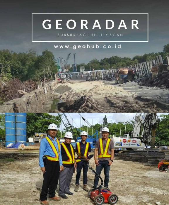
Geohub is a partner and solution for mapping underground utility locations.
With an expert team and using Georadar technology, underground utility locations can be accurately mapped to reduce damage and avoid during the excavation process.

PENETRATION DEPTH

Technically speaking:

  1. High frequency antennas (with a wavelength very small and very high resolution; 1.5–2 GHz antennas), for high detailed investigation of concrete structure (rebar location, etc). Depth of penetration < 50 cm

  2. Intermediate frequencies, 250–500 MHz antennas are used in most applications (underground utilities location, archeology, etc.); Depth of penetration 3–6 m

  3. Low frequencies, ie 100–200 MHz antennas, characterized by longer wavelength and lower resolution capabilities. They can reach 10 m depth, but can only identify big structures of minimum dimensions of some decimeters.

GEORADAR CONCEPT

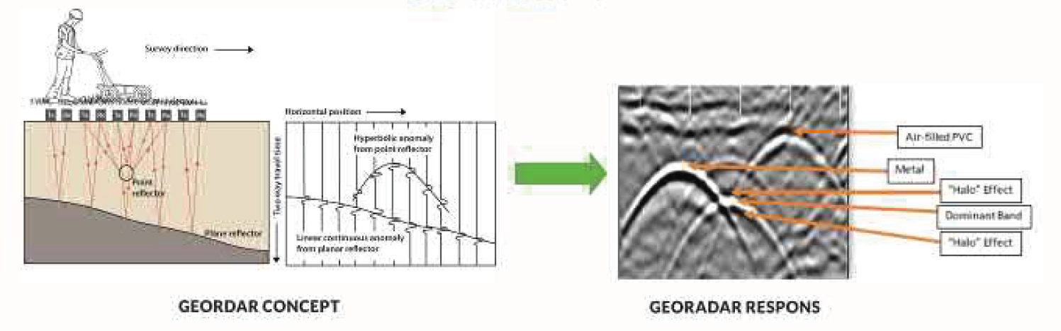
Georadar use the radar waves that emitted through the transmitter to subsurface and when the waves touch the objects that have different physical properties, the waves are reflected back to the receiver and the information of condition and buried objects can be identified.

GEORADAR ELIMINATES

  • Project delays

  • Work accident

  • Utility conflict

  • Pipe leak

  • Lost time

  • Redesign cost

  • Extra work orders

  • Higher construction cost


AIRBONE LIDAR MAPPING

Geohub is a leading LiDAR data service provider to worldwide clients. Our team have been involved in all types of LiDAR technologies and advanced LiDAR processes. Geohub provide high resolution data deliverables at cost effective prices to its clients across the globe.

Geohub LiDAR Service supports your operations with a full line of geospatial services. From the acquisition of the photography and LiDAR data, ground control and survey, to the delivery of the digital 3D mapping data, orthophotography, terrain models, LiDAR classification, and/or GIS solutions, all of which can be produced in-house. This enables us to tailor the QA/QC of any project to best meet your schedule and specifications. Our breadth of services complements our corporate culture and reputation for producing geospatial services known for quality, accuracy, and timeliness.

Geohub LiDAR service can be dispatched to quickly take care of your geospatial project needs. Our LiDAR systems provide high-speed and incredibly accurate elevations from fixed-wing and helicopter aircraft over large and small areas.

LiDAR APPLICATIONS

  • Mining

  • Oil & Gas

  • Urban planning & modelling

  • Palm Oil Plantation

  • Land Use Planning & Management

  • Transportation Engineering & Planning

  • Flood Plain Analysis

  • Asset Management

BUILDING INFORMATION MODELLING

Building Information Modelling (BIM) is an intelligent 3D model–based process to inform and communicate project decisions. Parametric design, visualization, simulation and collaboration provide greater efficiency for all stakeholders across the project life cycle to improve the design, construction and operations of facilities.

At its core BIM uses:

  • 3D models – components represented by digital objects that contain data regarding graphics, attributes and parametric rules that allow them to interact in an intelligent way.

  • Common data environment (CDE) – the single source of information (typically cloud-based), used to collect, manage and disseminate document models and non-graphical data for the whole project team. Creating a single source of information facilitates collaboration among project team members and helps avoid duplication and mistakes.

The implementation of BIM has a significant impact on the entire process of developing, executing and managing infrastructure projects, which includes surveying and data collection, conceptual design, environmental review, public participation, final implementation of design and documentation, bidding, construction, operations and maintenance.

The application of BIM is more evident in the design phase than it is in the construction and operation phases because there are many activities taking place during the design phase.

SATELLITE IMAGERY DATA & DEM DATA

Geohub is the leading provider of high resolution Earth imagery. With the most sophisticated commercial satellite constellation in orbit and cloud-based platforms that enable analytics and information extraction at scale. Geohub provides satellite imagery data and DEM data that gives customers the confidence to make critical decisions.

In addition, the provision of high-resolution Earth imagery is not only about data delivery, but also a strategic foundation for Geohub’s vision to build a Big Data Intelligent Center. This center integrates massive volumes of geospatial datasets into a unified ecosystem where advanced analytics, AI, and cloud computing converge. By transforming raw imagery into predictive models and actionable intelligence, Geohub empowers governments, enterprises, and industries to anticipate challenges, optimize resources, and make smarter, faster, and more sustainable decisions for the future.